|


|
Trekking in Nepal in the Annapurna Area . The Natt Guidebook and the maps On this page you will find information about the guidebook : Trekking in the Annapurnaarea along the new NATT-trails which avoid the road The second Ebook edition is published in September 2013. it decribes the Annapurna Circuit AC, Tilicho lake, The Annapurna panorama & poon hill trek. The Annapurna Base Camp trek and the new Khopra Dhanda and Mardi Himal trek Guidebook paperback, Guide book as an Ebook, Get a PDF, maps of the Annapurna Area Guidebook Trekking the Annapurna Circuit along the new NATT-trails which avoid the road and trekking south of Annapurna
|
|||
 4th
4th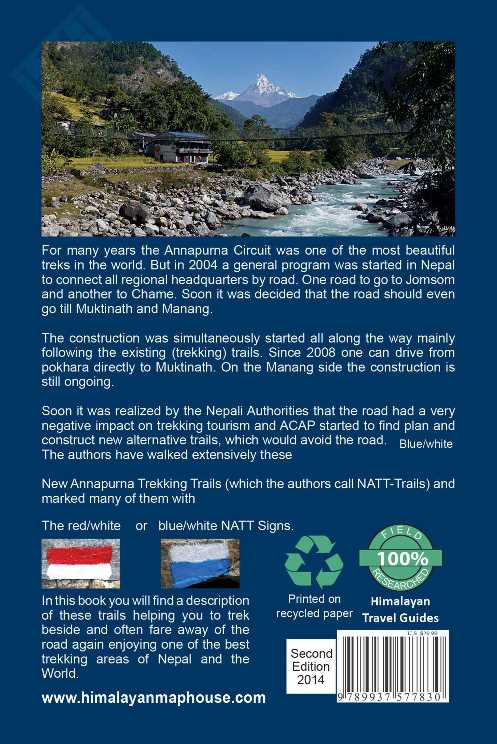
 |
Printig your own pages from a PDF file:
Attention: actualy this is not possible
 i
i
.
See the tabel of content:
Trekking in the Annapurna area along the new NATT-trails which avoid the road
About the Authors
Foreword to the first edition
Foreword to the second edition August 2013
Painting the Himalayas
Trail Status January 2013
General facts about trekking
Trekking Seasons
Arriving in Nepal
In Kathmandu
Getting the Permits:
Life on the Trail
Porters and guides
Getting to the Annapurna Region:
Going directly from Kathmandu to Besisahar/Bhulbhule:
Going first to Dumre then to Besisahar
Trail description with NATT trails
Possible schedules
The trail descriptions:
1.Trekking from Begnas Tal: 3 extra days
2. From Besisahar (810 m) to Bhulbhule
3. Bhulbhule –Bahundanda-Germupath
4. Alternative High route from Germu to Jagat high route 7 hours
5. Syange-Jagat on the road 2.5 hrs.:
6. Jagat – Chamje on the road 1:30 -2 hours:
7. Chamje to Tal: 3 - 4 hours
8. Tal to Dharapani: 2,5 – 4 hrs.
9. Dharapani – Bagarchhap- to Danaqyu on the road:1,5hrs..
10. Nice Side Trip: Dharapani- -Odar*-Bagarchhap Blue/ white 2 hours
11. Dharapani to Danakyu on the left east side of the river 2h *
12. Danaqyu –Temang 1:45-2 hours:
13. Temang – Thanchouk–Koto- Chame (2670 m) 3-3.5 hrs..
14. The Naar Phu Trek
15. The former trail by Latamarang:
16. Chame - Bhratang–Dhukur Pokhari 5-6hrs.
19. Dhukur Pokhari – Lower Pisang, Humde. and the Lower Route to Manang:
20. Dhukur Pokhari – Upper Pisang and the High Route to Manang
21. (Upper) Pisang to Ghyaru 2-2.5 hours
22. Ghyaru – Ngawal 2 – 2.5 hours
23. Ngawal to Braka (Braga) 2.5 or 3.5 to 4 hours
24. Julu to Braka on the high route * 4 hours
25. Braka*** (Braga) 3470 m
26. Milarepa’s Cave ** ~ 4000m 3 - 3.5 hours: blue/white markers
27. Ice Lake ** 4 -5 hours: blue /white NATT marks
28. Braka – Manang 35 min:
30. Side Trek to Khangsar, Grande Barriere and Tilicho Tal (Lake)
31. Going directly from Khangsar to Yak Kharka
32. Going to Tilicho Lake ***
33. Crossing Tilicho Lake to Jomsom
34. Going from the new Shree Kharka Lodge to Thorung La
Crossing Thorung La & the Dangers of Acute Mountain Sickness:
35. Manang to Thorong Phedi or high camp
36. From High Camp over Thorong La to Muktinath 6-10 hours
39. Muktinath ***
40. Muktinath-Ranipauwa to Jomsom
41. Trek Ranipauwa to Lubra (Lupra) and Jomsom:
Walk to Jharkot and from there over Lubra to Jomsom **
42. A wonderful day trip to the villages of the Muktinath area.
43. Daytrip – Muktinath/Ranipauwa& temple – Purang – Jharkot – Muktinath
44. Muktinath Ranipauwa-Chongur-Jhong to Jharkot (4-6 hrs.) Round trip back to Muktinath
Jharkot **
45. The Jharkot sightseeing tour ** with blue marks
46.From Jharkot to Ranipauwa/Muktinath by Purang
47. Jharkot to Lubra
50. Ranipauwa and the northern trail to Kagbeni ***
Chongur **:
Jhong **
My love - Kagbeni ***
51. Half-Day Trek Kagbeni-Tiri** m:2-3 hrs.
52 High Route From Kagbeni up to Muktinath
53. Kagbeni – Jomsom standard route on the road
54. High route from Kagbeni to Jomsom ** 6-8 hrs.
Jomsom (2720 m)
Jomsom to Tatopani
60. Jomsom to Marpha via Thini and Dhumba Lake
Marpha ***
61: Marpha - (Tukuche) - Kokhethanti Eastern NATT trail
62. Crossing the Kali Gandaki from Chokopani to Tukuche in the dry season.60
Tukuche:
63. Western Trail Tukuche -Khobang-Larjung (right riverside)
64. Western Kali Gandaki trail: Naurikot***
65. The two beautiful lakes below Dhaulagiri:
66. Climbing to the Dhaulagiri Ice fall (3-4 hours)
67. Roundtrip Larjung- Naurikot-Buddroso Lake- Sekung Lake
68. Kokhethanti to Kalopani or Kokhethanti - Titi Lake, Taglung - Kalopani
Kalopani / Lete
69. The NATT- trail bypassing Kalopani and Lete
70. The forest trail from Lete to Ghasa* (4 hours-red /white marks)
Ghasa 2010m:
71. Ghasa to Tatopani (8 hours)
Dana
Tatopani – Pokhara by Bus or Jeep
72. From Tatopani to Ghorepani and Poon Hill ***
Part 2: Trekking South of Annapurna:
The people living south of Annapurna
The Annapurna Panorama Trek/ Poon Hill trek clockwise (75-79)
75. Pokhara to Nayapul- Hille/Ulleri Ghorepani (1.5 to 2 days)
Ghorepani 2860 m:
Poon Hill *** (3193m + 7m tower! )
76. Ghorepani to Tadapani / Ghandruk 5-6hrs.
Old Ghandruk ***
78. Ghandruk – Birethanti – Nayapul 3 to 4 hrs.
79. Ghandruk – Landruk –Tolka –Bishok Deurali – Pothana –
80. Pothana to the road and to Pokhara
The Annapurna Panorama Trek/Poon Hill Trek anticlockwise
81. Pokhara to Pothana
82. Pothana –Pitam /Bishok Deurali 2100m Tolka-Landruk(4-6 hrs.).-
83. Landruk-Ghandruk***1940 m-Tadapani** 2654m
84. Tadapani to Ghorepani 6-8 hrs.
Ghorepani 2860 m:
Poon Hill ***3193m + 7m tower
85. Ghorepani to Birethanti and Nayapul to Pokhara 7- 8 hrs.
The ABC Trek /Annapurna Base Camp Trek
91: Landruk-Chhomrong (See Pokhara to Pothana to Landruk trail description)
92: Ghandruk- Chomrong 4-5h
94. From Tadapani to Chomrong. Total 5 - 7 hrs.
95. Chhomrong-Bamboo-Dovan 4.5-6 hours
96. Dovan to Himalaya Hotel (2820m) to Deurali 1.5 hrs.
97. Deurali to MBC and ABC 4-5hrs.
98. Going back from ABC
100. The Mardi Himal Trek (written by Prem Rai)
101. Pitam Deurali – Forest Camp (Kokar) 2550m (5 – 6 hrs.)
102. Forest Camp (Kokar) – Rest Camp (2700m) - Low Camp (3000m)
103. Low Camp (Humal) – High Camp (Kew) 3900m (4 or 5 hrs.)
104. High Camp – Upper View Point 4450m – High Camp (7 – 8 hrs.)
The Khopra Danda Trek (Written by Prem Rai)
Khopra Trek clockwise
110. Day 1: Pokhara-Nayapul-Purnagaun (5-7hrs. including driving)
111. Day 2: Purnagaun to Lespar
112. Day 3: Lespar to Nangi 2260m. (6 – 7 hrs.)
113. Day 4: Nangi to Moharedanda 3300m. (~7 hrs.)
114. Day 5: Moharedanda to Swanta
115. Day 6: Swanta to DhanKharka/Chistibang
116. Day 7: Dhan Kharka /Chistibang to Khopra Danda 3660m (3 – 4 hrs.)
117. Day 8: Khopra day trip
118. Day 9: From Khopra Danda to Tatopani
119. Day 9: Khopra Danda (Ridge) to Bayeli (Bayeli Kharka) 3460m (4 – 5 hrs.)
120. Day 10: Bayeli Kharka to Tadapani
121. Trekking the Khopra Danda Trek anticlockwise.
Pokhara ***
What to do in Pokhara?
Continuing from Pokhara:
Postlude
Maps of the Annapurna Circuit
i recommend the maps of Himalayan Maphouse /Nepamaps as they quickly marked the new NATT trails in their Maps.
You can find these Maps in Nepal and at Amazon UK


NA 503 Around Annapurna New Edition 2016! scale 1:125.000 . This map covers the whole AC Amazon.uk
NA 506 Muktinath to Jomsom- der Jomsom Trek scale 1:80.000. The Jomsom side including many treks south of Annapurna amazon.uk
NA 501 Annapurna Base Camp scale 1:50.000 . Treks south of Annapurna and to the Annapurna Basecamp.amazon.uk


NA 509 : Naar Phu scale 1: 75.000 it shows the upper Marsyangi Valley (Manang)
and the classic 7 day trek to Naar and Phu. it is an exellent map for people who spend some days in the Manang area amazon.uk
NA 521 New Naar Phu Circuit. scale 1:125.000 This maps covers also some more high passes in the north and shows the “7 passes annapurna circuit” which can only be done with tents in an organised group. amazon.uk
CL806 Pisang Peak 1:50:000. This map shows the upper Marsyangi Valley and the routes to pisang peak. As there is much less snow nowadays on the peak, the approch routes might have changed. amazon.uk
see the homepage of himalayan maphouse http://himalayanmaphouse.com/
Overview Annapurna area
