|


|
Nepal, Trekking around Annapurna - the Manang side
Annapurna Circuit: on this page you will find information and pictures of the trail from Manang to Thorong Phedi and to prevent the dangerous altitude sickness
you can enlarge most small pictures by clicking in on of the corners.
Plan 2 days because of the need for proper altitude acclimatization. Even when it is possible to reach Thorong Phedi from Manang in a long day, you should absolutely pass one night either in Yak Karkha or Churi Ledar and a second night in Thorong Phedi or high camp. Otherwise you might have a higher chance of altitude problems Crossing Thorung La & the Dangers of Acute Mountain Sickness: Trekking in Nepal can take you to altitudes where the body needs to make many physiological adjustments. Above 3500 m not only oxygen but also CO2 will diminish and therefore one not only has to breathe faster and deeper, but also the acidity of the blood has to be regulated and there is even an impact on the cell membranes. This adaptation will take several days and if you climb up too fast your body might have not enough time to adjust. This can lead to very serious and sometimes deadly problems. In my view, it is totally irresponsible to spoil a vacation just because one neglects to follow some well-known precautions. As written above, Acute Mountain Sickness (AMS) is caused by physiological responses and not by a lack of fitness. Super-fit people may even have an increased risk as they are inclined to go up faster and are used to suffering to achieve their goals. Planning: Be aware that you will have to trek slower that your legs are willing to go. The general rule is that after reaching 3000m one should not sleep more than 500 m higher than the night before. My experience is that you can sleep up to 700 m higher for one night but you should not do it on consecutive days. It is essential to have more than one day above 3500 m before starting the ascent of the valley leading to Thorung La. If you plan to do the AC clockwise, acclimatization is even harder as Muktinath is still below 4000 m. In this case you should plan to spend at least 3 nights there. I have seen many very sick people who had climbed too fast. Planning a schedule with enough time for acclimatization is the most important thing for ensuring a successful and enjoyable trekking tour. In Kathmandu: Buy some tablets of the emergency drugs Dexamethasone and Nifedifin . They are amazingly cheap and could help a lot if you have serious acclimatization problems. Diamox is useful as it helps you sleep better but it will not help you if you are in serious trouble. What is normal at higher altitudes? When you reach above 3000 m you will realise that you are out of breath faster and are walking more slowly. By the next morning you will already be stronger. So day by day your body adapts itself to the higher altitude. At night you will sleep much lighter, sometimes being awake for hours. But the next morning you will be rather well-rested. Sometimes it will take you 2-3 days to have a good sleep. But on the way down you will sleep like a log. It is also common that you wake up in the middle of the night, gasping for air and with your heart beating like a heavy metal drummer. Don’t panic, it’s just the breathing regulation which was not yet perfectly adapted during the sleep when you normally breathe more slowly. Soon you will be OK. Light headaches also often occur and one may notice that fingers or even the face is slightly swollen. AMS or Acute Mountain Sickness: symptoms are light headache, loss of appetite and light nausea. Realise that this could be the beginning of much more severe symptoms. Stop going up or have a rest day till that you feel better. If you have stronger headache or nausea you even should go back to the last place where you felt fine. Diamox may help you as it speeds up the acclimatization process.
HACE High Altitude Cerebral Oedema: Your brain is floating in a liquid, which is permanently produced and drained away. As an effect of bad adaptation brain cells will hold more liquids, which leads to a higher pressure in the skull. This in consequence leads to a poorer supply of oxygenated blood and your brain will not work properly any more. The symptoms are a strong headache, loss of balance, vomiting and possible sight or hearing problems. People sometimes behave like they are badly drunk. This includes a refusal to accept at all that they have a problem.
As soon as you are not able to walk a straight line properly anymore, you have a serious problem. It might just take another half- hour for you not to be able to walk by yourself at all. The only cure is to descend as fast as possible. Do not continue. The emergency drug Dexamethasone (initial dose 8 mg then 4 mg every 6 hours) can have a dramatic positive effect helping you to go down on your own. Sometime people feel completely relieved, but this effect is dangerous and deceptive as Dexamethasone does not help with acclimatization. If you are just below Thorong La, you might be tempted to cross it as the descent is much faster on the other side. However, go back down and give your body the time it needs at lower altitude. I have met people who had to turn back from Thorong La because of horrible headaches and vomiting and could cross it the next day without any problems! Don’t spoil one of the best experiences in your life by pushing too fast.
HAPE High Altitude Pulmonary Oedema: As fetus, you didn’t need strong blood
circulation in your lungs. As an energy-saving measure, Summary: The most important precaution is to allow your body to adapt to altitude. If you are in distress because of severe symptoms of HACE and HAPE, the emergency drugs Dexamethasone and Nifedipine can help you to descend immediately on you own. If you have strong symptoms but are not sure what type of altitude sickness it is you might take the so called Margarita cocktail (8 mg Dexamethasone, 20 mg Nifedipine and a tablet of Diamox which was developed at the Swiss altitude Research Station in the Margarita mountain Shelter. In any case, going down is the only real and safe cure! Going up the valley north of Manang
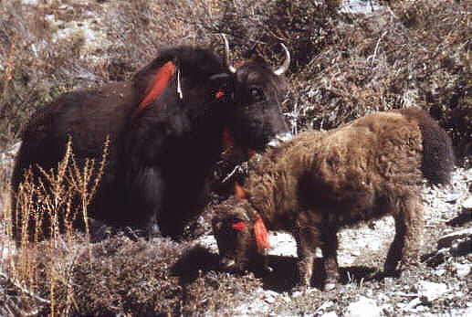
Above 3000m you will see Yaks. These peaceful animals dont stay below 3000m as there the air is far to thick to breathe. Pure yaks dont give much milk, so that they are often interbreed with cows. Yaks have long hairy harems pants and a typical ”horsetail”. Female yaks are called Nak, so that yak cheese is pretty silly, isn’t it.
Manang to Yak Kharka or Churi Ledar 5 - 6 hours: Walk through the village of
Manang to the western end. The trail is clearly visible and on the hill you see a big new white stupa and the upper village of Thanki Manang. Going up to Thanki Manang
Thanki Manang with Annapurna 2 and Annapurna 4 Descend till the Mani wall; here the trail to Khangsar turns to the left (there is just one blue/white mark at the beginning). Continue going uphill following the red /white marks and go through the village of Tanki Manang, which has one lodge. Continue on the very clear trail till you reach the two lodges of Gunsang (3900m). After Gunsang cross the bridge and continue. You will reach a shelter and an area with big stupas and a big Mani wall. Here the upper trail coming directly from Khangsar rejoins the main trail, so that you could also easily come from Khangsar to Yak Kharka or Churi Ledar in one day.
Little break in Gunsang Shelterplace
going up the thorong valley
From Gunsang to the next settlement of Yak Kharka you will need around 2 hours. Yak Kharka (~4000m) has 5 big lodges, with the first 4450 m and the last one being separated by a 25 min. walk. The other three lodges are in the middle part. It will take you another 40 min to Churi Ledar (4200m). Here you will find only two lodges and a teashop. For people who have absolutely no problems with altitude-related symptoms it makes sense to continue to Churi Ledar (instead of stopping for the night at Yak Kharka) as they will sleep 200 m higher. This makes the next day to Thorong High Camp (4830m) an easier one. Instead of an 830 m altitude gain from Yak Kharka, you would only gain 630 m, which is much closer to the recommended maximum 500 - 600m per night.
During oure monsoon trek i waited for my friend Prem Rai who was taking many photos of the flowers. If you stayed in Yak Kharka, it would be best if you stay the next night in Thorong Phedi at an altitude of 4450 m. If you have come by the high route via Ngawal and stayed one night in Braka/Manang and one night in Khangsar, you can go to Churi Ledar and should not have any problems.
Churi Ledar to Thorung Phedi 2 hours red/white marks: Just go up the trail (red /white NATT marks) with some up and downs above the river till you see a trail on the other side of the river. At the junction choose the left trail with the NATT signs; the right one will stay on the same side of the river, climb high above Thorong Phedi to descend in a dangerous or risky path. It was built several years ago to avoid the dangerous landslide area on the other side, but then it was realized there were many more serious accidents on this new trail they switched back to the old one.
Soon you will see a suspension bridge. Even when the main trail seems to continue straight on, take the trail left leading down to the first suspension bridge. On the old trail you would have to descend to the wooden bridge through a slippery landslide area with frequent and dangerous stone fall.
new bridge old bridge Cross the river and climb the trail passing by two little teashops. From here you can already see at the end of the valley the houses of Thorong Phedi. About 20 minutes after the teahouse you will have to cross for 15 min a landside and stone fall area, which begins after the signpost. This is really a very dangerous stretch and several people have been injured here by falling stones and a least one person has been killed.
Be careful!
The landslide an rockfall area seen from the old trail. One can imagine that this is a really dangerous stretch. I'd recommend, therefore, that you be very cautious and alert while crossing the danger zone! Always look and listen for potential rock fall. As a second and important safety measure you should keep at least a distance of 20, or better yet, 30 meters between each person. In this way it is much easier to quickly find shelter or a safe place behind a rock. And if someone is hit the rest of the group can help the victim.
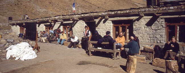
After this landslide stretch the trail continues at about the similar level for 15 min until you reach the two lodges of Thorong Phedi at 4550m. In 1981 there was not even one single shelter between Manang and Muktinath. At Thorong Phedi there was just a little shelter for shepherds with only half a roof left as someone had taken away a part of the roof for firewood. Recognizing a business opportunity, this situation prompted a visionary local named Michung Gurung to build a small lodge. In time it grew into a full complex of sleeping rooms with a huge dining hall.
Thorong Phedi 4450 m
thorong phedi in monsoon and winter
it is not so far from Yakkharka or Churi lethar so most trekkers enjoy alzy afternoon Overview Annapurna region No. 29 Braka to Manang
  To the page To the page
|
||||||